The Environment and Space: A Long-Term Relationship
Environmental protection, the optimization of natural resources, minimization of waste and the reduction of pollution are the responsibility of society as a whole. Above all, it is an individual responsibility, backed up by the right laws and involving all sectors.
The aerospace industry has played, and continues to play, a key role in this struggle.
The study and care of the environment has always been one of the prime concerns of the aerospace sector. Today it takes the form of mitigation measures, climate change resilience, and adaptation, but it began back in the 1960s with weather-monitoring satellites.
The TIROS-1 satellite, launched by NASA in 1960, is considered to be the first successful meteorological satellite; as such, it was the forerunner of the Nimbus program, which placed meteorological satellites into orbit for more than a decade (1964-1978). This program was crucial in allowing the various international space agencies to carry out their Earth observation programs.
All the world’s space agencies (ESA, JAXA, NASA, INTA, CNES, etc.) run their own Earth, environment and ecosystem monitoring programs. The European Space Agency (ESA), for example, has 13 Earth observation satellites currently up and running with another 28 in the pipeline. These are grouped in scientific development programs like Earth Explorer Missions and in operational meteorology and Sentinel programs. The Earth Explorers are currently geared towards increasing our understanding of how the ocean, atmosphere, hydrosphere, cryosphere, and Earth’s interior all operate and interact as part of one interconnected system. CryoSat-2, which studies the thickness of the polar ice caps, SMOS, which analyzes ocean salinity and soil moisture, and EarthCARE, which will investigate interactions between clouds, particles suspended in the atmosphere (aerosols), and solar radiation, are all examples of environmental investigation missions. ESA’s meteorological missions, carried out in collaboration with EUMETSAT, include the MetoOP program and the Meteosat satellites. These respond to society’s need for more accurate weather forecasting and the monitoring of climate-based biophysical variables like the ozone layer, greenhouse gases, precipitation, and surface temperature.
GMV exploits Copernicus information and develops additional geospatial products from Earth observation data in order to meet its clients’ environmental information needs.
This information crucially allows numerical prediction models to give 3- or 5-day weather forecasts, the chemical transport models to estimate air quality, and the global circulation climate models to predict the climate in the next century. The Sentinel satellites are the space segment’s contribution to the European Union’s environmental monitoring program Copernicus. Seven Sentinel satellites have now been launched, three more are being built with six more under study for future development. The information gleaned by these satellites is used to define products around the six thematic areas of the Copernicus program: ocean, land and atmosphere monitoring, emergency response, security, and climate change. These services will help in urban planning, regional and local planning, silviculture, fishery, healthcare, civil protection, infrastructure, etc., from a viewpoint of sustainable development and nature protection.
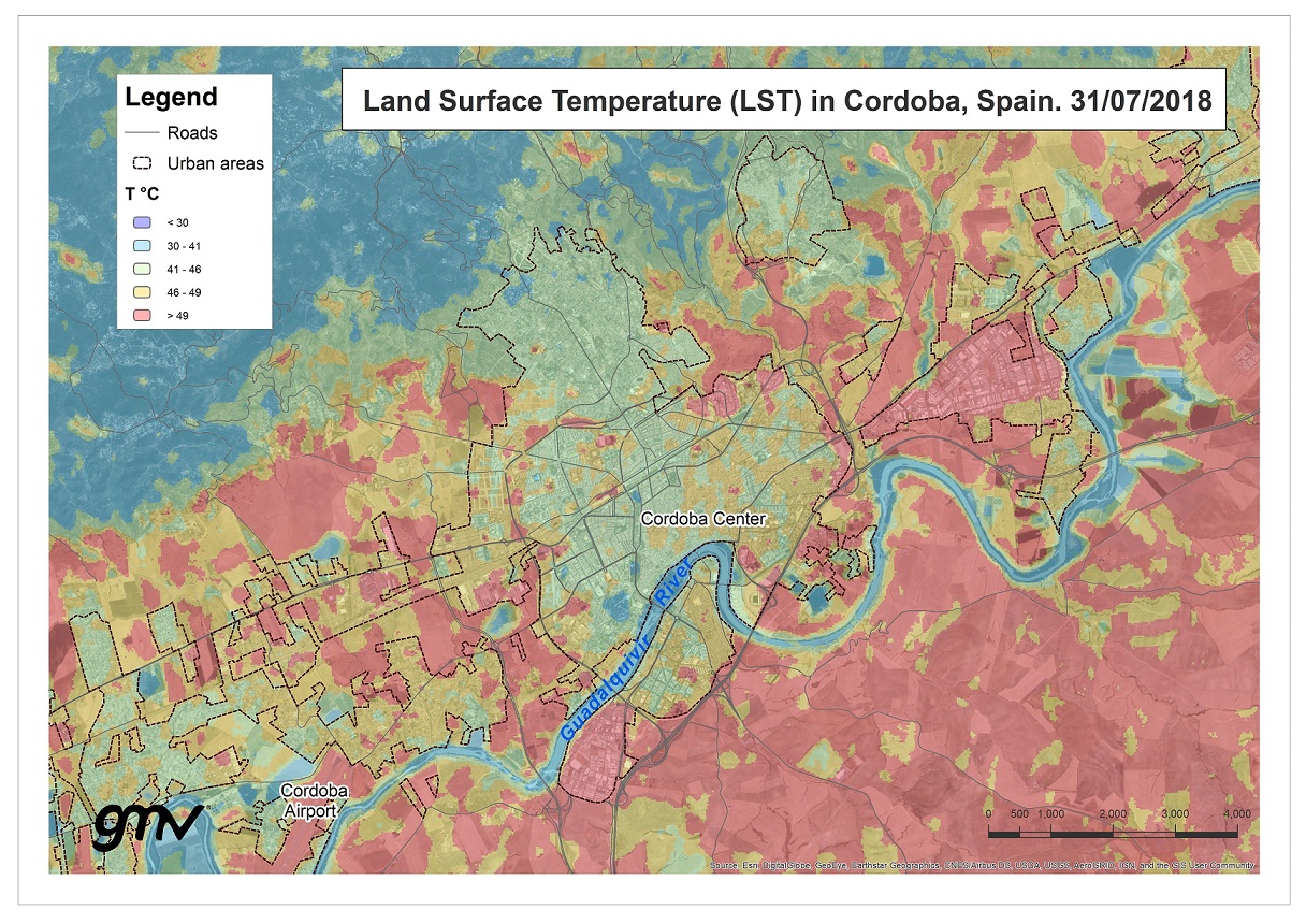
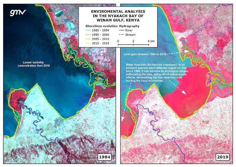
GMV exploits Copernicus information and develops geospatial products from Earth observation data in order to meet its clients’ environmental information needs. For example, it takes part in Copernicus’s emergency service, analyzing the pre- and post-disaster situation (floods, earthquakes, cyclones, etc.). It collaborates with the European Commission to encourage sustainable farming, proper management of natural resources, and conservation of biodiversity in Africa. It runs a project for sustainable European forestry using Earth observation and other remote-sensing data. It participates in the definition of a new type of aerial platform (high-altitude pseudo-satellites: HAPS) for monitoring city air quality. It supports international financial institutions like the World Bank, the Inter-American Development Bank, and the Asian Development Bank in the use of Earth observation data for analyzing environmental risks like degradation of natural resources and food security. GMV also studies the pressure human migrations exert on natural resources. Understanding which climate changes spark migrations and the impact of internally displaced person camps on the environment is vital for heading off human tragedies and staying one step ahead of future migratory movements.
The social perspective is vital for improving environmental protection. Understanding and promoting the improvement of human capital and social stability are sine qua nons of planetary protection. The United Nations’ Sustainable Development Goals aim to wipe out poverty, protect the Earth, and ensure prosperity for one and all as part of a 15-year agenda. To achieve these goals we all need to pitch in: governments, private businesses, and society as a whole.
Author: Carlos Doménech García