25 Years of the Copernicus Programme

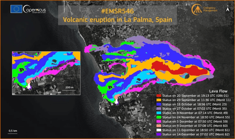
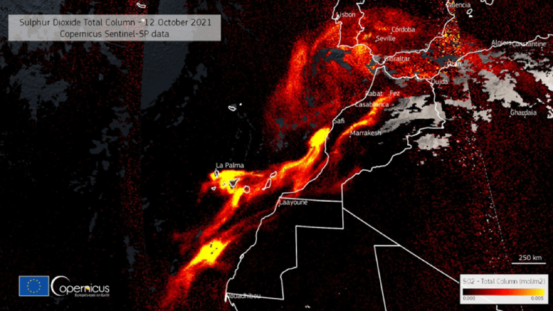
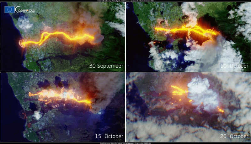
On September 19, 2021, the volcanic eruption of La Palma occurred in the area of Cabeza de Vaca. For three months, the Copernicus Emergency Service provided authorities, media outlets, and experts with products and data to analyze the impact of the eruption, make predictions regarding its future development, and undertake essential measures to protect the population.
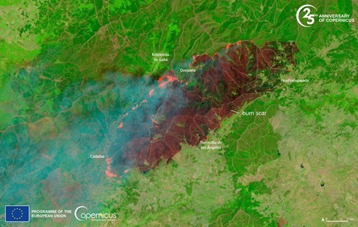
Recently, a fire swept across the regions of Las Hurdes and Sierra de Gata. Emergency services used Copernicus imagery to assess the fire's impacts and analyze its possible progression.
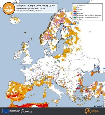
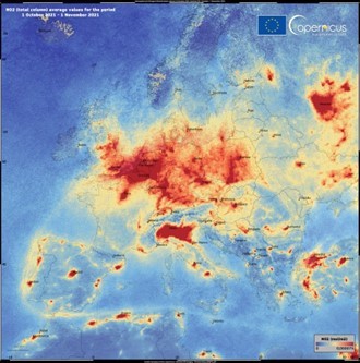
Copernicus also contributes to drought risk analysis and the Copernicus Atmospheric Monitoring Service is used to complement data from national air quality networks.
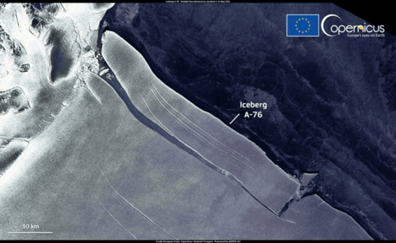
Other examples, in more distant locations, include tracking ice masses or monitoring migratory movements compelled by diverse humanitarian crises.
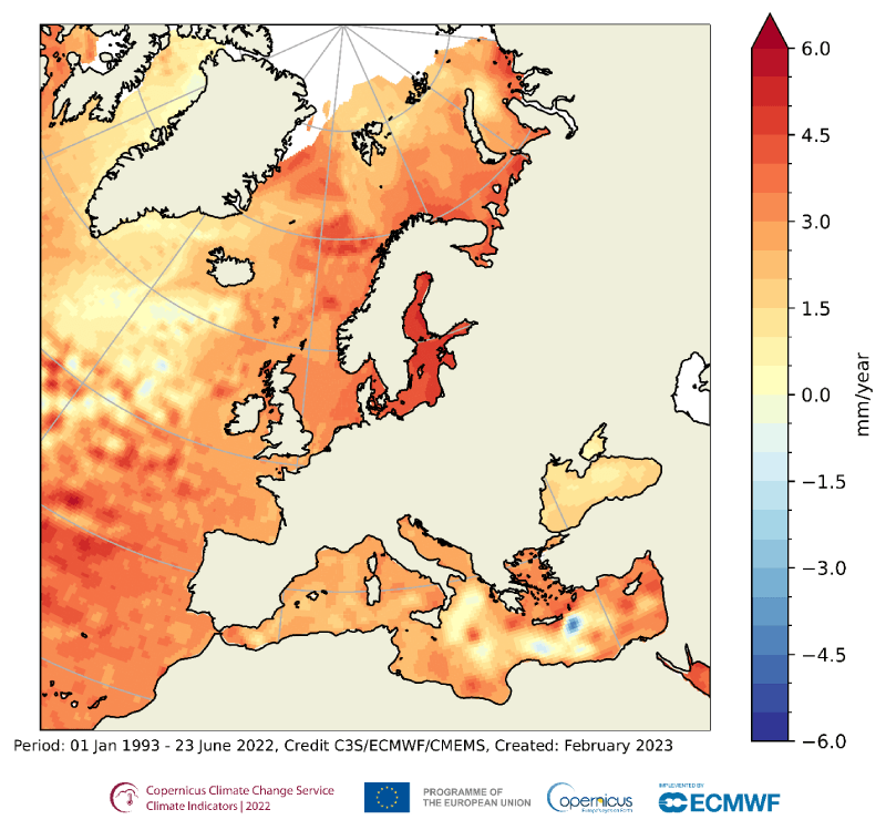
The effects of climate change can be observed through maps that depict sea levels in various regions.
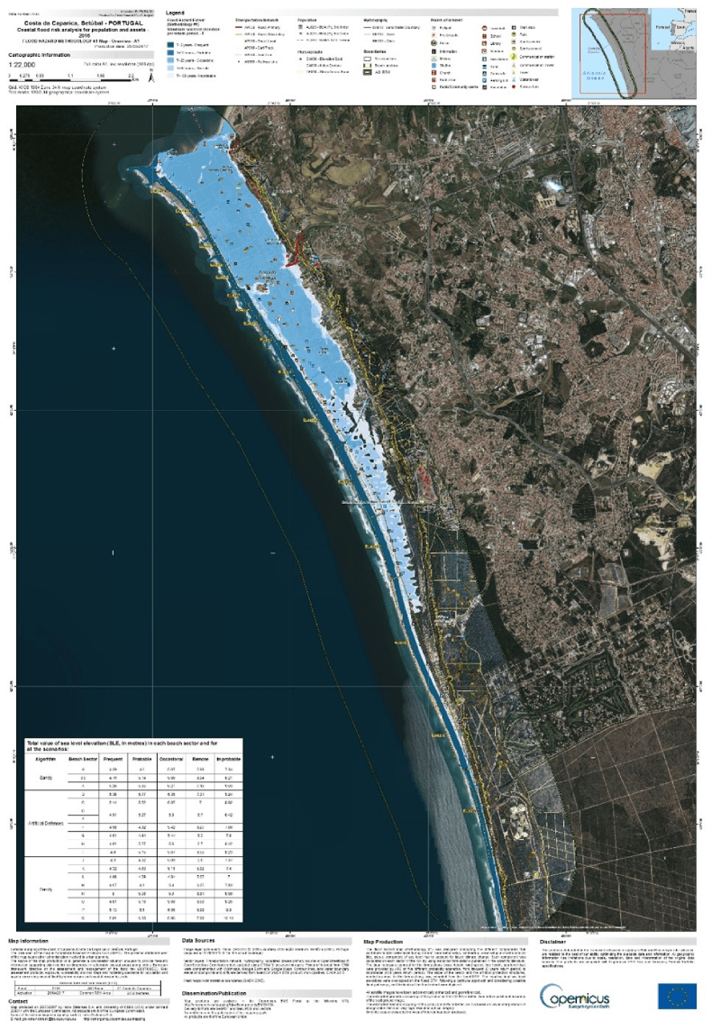
We also have flood risk maps for coastal regions as tools for the prevention of natural risks.
These are just a few examples, some of them immediate, illustrating the effective use of the Copernicus programme. The programme was launched in 1988 with the signing of the Baveno Manifesto, which proposed the establishment of the European environmental monitoring program initially referred to as GMES (Global Monitoring for Environment and Security), later rebranded as Copernicus.
Overview of the Copernicus Programme
Copernicus was structured around a space component and a services component for management and decision-making in six areas: climate change, the atmosphere, marine environments, land use, emergency response, and security.
The following Figure provides an overview of the different components and their interactions:
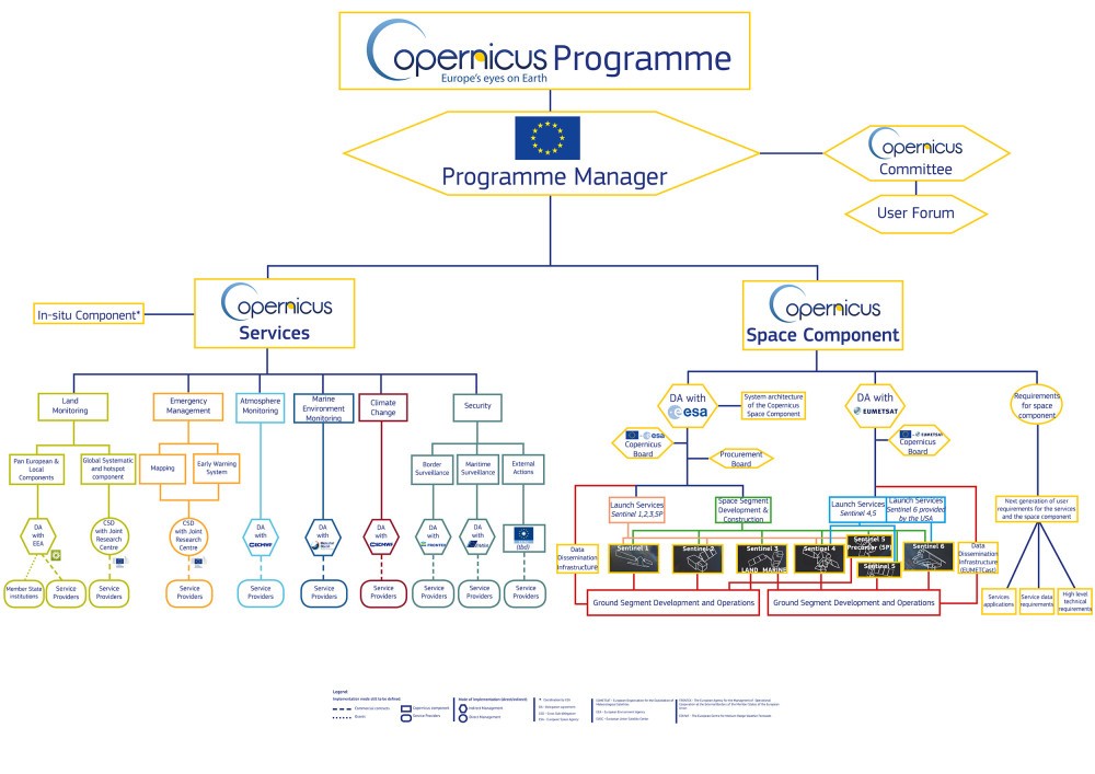
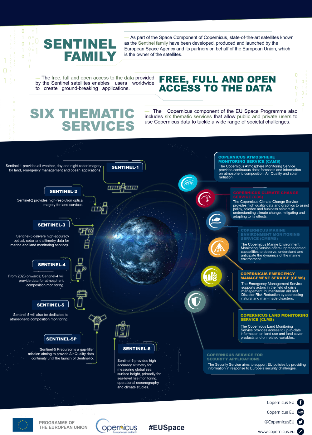
The Copernicus space segment consists of the Sentinel constellation of four satellite families (Sentinel-1, -2, -3, and -6), two instruments onboard the Eumetsat weather satellites (Sentinel-4 and -5), Sentinel-5P, the precursor of Sentinel-5, and the participating missions, which comprise commercial or public satellites that contribute their own data to the program.
Sentinel-1A was the first satellite to be launched in 2014. There are currently seven Sentinel satellites in operation providing 20 TB of data daily in the areas mentioned above. The Copernicus data can be accessed through the Copernicus Data Space Ecosystem.
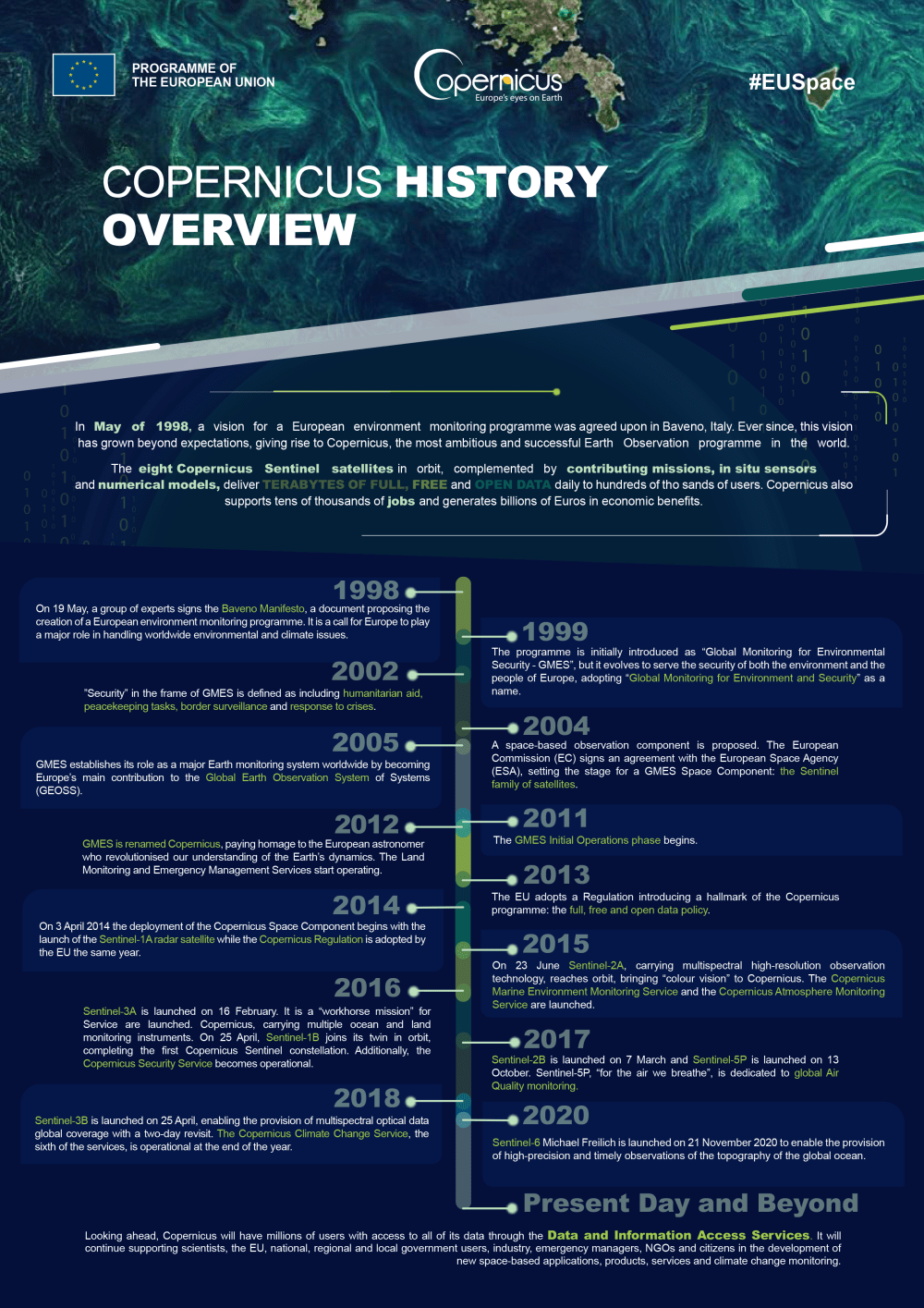
The following Figure presents an overview of the history of Copernicus, from its inception to the present day.
The Value of Copernicus
Some numbers
From 2000 to 2013, €3.2 billion were invested, with 76% (€2.4 billion) dedicated to the space component, primarily for the development of Sentinel satellites. Between 2014 and 2020, an investment of 5 billion euros was made, with 86% (€4.3 billion euros) allocated to the space component. Looking ahead, the budget for the 2012-2027 period exceeds 5 billion euros.
The most widely used data sources are the Sentinel-1 and Sentinel-2 satellites, followed by Sentinel-3 and Sentinel-5p. There is a user base of over 700,000 registered users, with a volume of data downloads surpassing 550 petabytes. Additionally, more than 62 million products have been published.
In terms of its impact, it is projected that every euro invested in the space component will yield a gross added value of 1.4 euros, excluding the exploitation impact.
But what is the differentiating factor?
Copernicus can be described as a multi-mission Earth observation system that delivers exceptionally high-quality data, ensuring global coverage, based on a policy of open and free data. These characteristics have contributed to the widespread use of Copernicus worldwide, leading to the system undergoing a continuous process of validation and enhancement.
Copernicus is a complete programme in several aspects: first, it covers the entire value chain including the space segment, the ground segment, and the user segment to create products and services for end users. And second, it is a multi-mission program, meaning that to cover the widest range of possible services for the final user, the satellite constellation encompasses a diverse and complementary suite of instruments, including multispectral imaging spectrometers, synthetic aperture radar, radar altimeters, and microwave radiometers. These instruments enable the monitoring of virtually every aspect of the Earth's surface, atmospheric composition, and ocean conditions.
The guaranteed continuity of missions is another added value of Copernicus that significantly enhances its usefulness, as it enables the continuous and homogenous monitoring of extensive areas. This facilitates the comparative study of short, medium, or long-term time series, making it a key tool in monitoring environmental policies.
Collectively, these characteristics set it apart from any other public or private observation system.
The Impact of Copernicus
The examples above are merely scratching the surface of the possibilities that the system offers and its impact across different socioeconomic and environmental domains.
Copernicus has successfully brought together users, researchers, academia, industry, and public administrations, making it an essential tool available to the decision-making bodies for defining and monitoring the policies that shape the lives of European citizens in the areas of production and economic development, the environment and climate change or health preservation.
Thus, Copernicus has emerged as a tool of indisputable value in monitoring the EU's commitment to climate change through the European Green Deal, which aims to achieve efficient use of resources with no net greenhouse gas emissions by 2050 and decoupling economic growth from resource use. Currently, Sentinel-5P mission delivers key constituents of the atmosphere with high spatio-temporal resolution,
Similarly, Copernicus supports European policies like the Common Agricultural Policy (CAP), which aims to ensure affordable food for citizens and a fair standard of living for farmers. The utilization of Sentinel-1 and Sentinel-2 satellites is benefitting all stakeholders, including farmers and the administration, by expediting inspections, streamlining payment processes and contributing to improved productivity.
Copernicus as a technological driving force
Copernicus is also undoubtedly a source of technological innovation. The vast amount of data generated by the system, its complexity, and its high diversity require access to cloud infrastructure to enable the use of mass data management and analysis techniques. Copernicus has been the driving force behind Ground Segment As A Service and new image analytical methods, based on artificial intelligence or machine learning techniques to define highly specialized solutions with high added value.
GMV in Copernicus
GMV has contributed to Copernicus in all its phases and along the entire value chain, from mission engineering and analysis to the provision of Copernicus data exploitation services. GMV is responsible for critical elements of the program such as the control center, mission planning, and precise orbit determination. GMV also plays a part in the development, maintenance, and operation of the infrastructure needed for end users to access and use all the Copernicus data.
However, as we have mentioned, our role goes beyond ensuring effective and accurate mission operations. We are also involved in data processing and analysis, extracting information that is useful for end users. In the past two years, we have utilized Copernicus data in over 40 projects, developing the following products and lines of action:
It is worth highlighting the projects we have undertaking concerning food security and droughts in Africa. Our contributions in emergency and security domains also deserve special recognition, as GMV supports the geo-intelligence requirements of the European Union’s Foreign Policy, civil protection policies, humanitarian aid, transportation, critical infrastructure protection, and more.
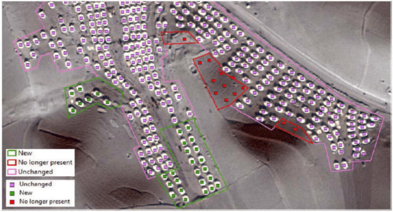
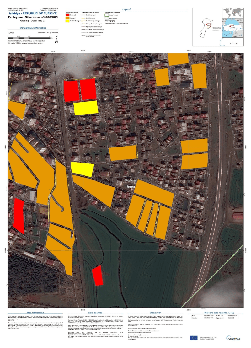
The following map was created by GMV in conjunction with the activation of the Emergency Rapid Mapping service as a response to this year’s earthquake in Turkey.
GMV has also shown its commitment to Copernicus by taking an active part in the Copernicus Relay, an organization for disseminating the program’s capabilities and promoting use of the data and services provided by this flagship European program, since its creation in 2017.
Copernicus and New Space
We are currently witnessing the rise of New Space as a new form of space sector development, where the key is to leverage new technologies and digitalization to remove some of the barriers that prevent or prevented the adoption of Earth observation in certain production sectors. The miniaturization of electronics, development of standards, and faster turnaround times are driving the “democratization” of space, broadening its user base.
Copernicus is not New Space, but it plays a pivotal role in its development, since the quality of the data it provides makes it the de facto reference system for validating and calibrating the performance of the data provided by the New Space systems. In addition, New Space will complement Copernicus in aspects such as revisit frequency, higher resolution images, and greater flexibility in replanning.
The Future of Copernicus
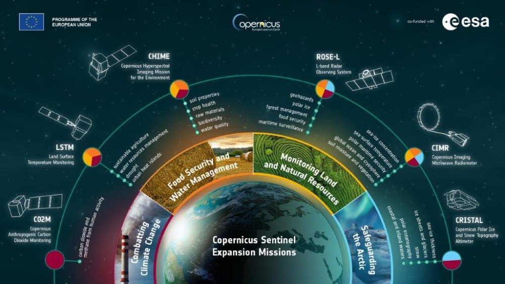
Looking towards the future, Copernicus is undergoing a continuous process of improvement, encompassing all its components, the space segment, ground segment, and services. In addition to ensuring the continuity and improvement of the existing Sentinel missions, the EU has embarked on a service expansion process that entails six new Sentinel missions that will enable the measurement of anthropogenic CO2 emissions, tracking of rising sea levels, and monitoring of various processes occurring in the Arctic.
The future of Copernicus lies in a deeper integration into users’ operational workflows, which calls for increased awareness of its benefits and ongoing enhancements in data accessibility, services, and information.
Similarly, Copernicus must further its role as a catalyst for technological innovation by keeping embracing techniques based on artificial intelligence, automated processing, supercomputing, data fusion, and quantum technologies for data processing and utilization.
“We must build the Copernicus of tomorrow around two objectives for Europe:
(1) a Europe which is pioneer in the battle for a green planet;
(2) a Europe which is resilient, and capable of projecting its own strategic power.”
These are the words of Thierry Breton, European Commissioner for Internal Market, underscoring the pivotal role of Copernicus in Europe’s ambitious pursuit of sustainability through the Green Deal.
Europe’s commitment to Copernicus is steadfast and enduring, and GMV supports that commitment and shares the passion of contributing to a system that serves as a vital link in the chain of actions aimed at preserving our heritage, planet Earth, for generations to come.
Author: Luis Mariano González Casillas